
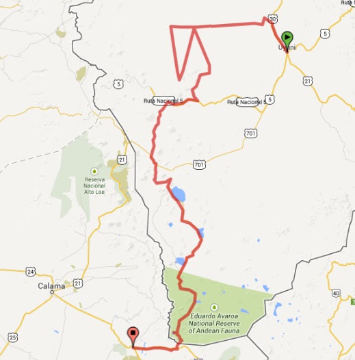
Route summary: Uyuni, Salar Uyuni, Isla Incahuasi, San Juan, Laguna Colorado, San Pedro de Atacama.
Days: 5
Zero mileage days: 0
Distance (point to point): 307km
Distance (driven): 668km
Inefficiency factor (Driven/P2P): 2.18
Avg. speed: 134km/day
Click here for detail.
The idea for the next leg came to me when I was around
Salta. I wanted to go to Uyuni, and I also wanted to see San Pedro and some of
the remaining northern bits of Chile, but the problem of the Andes reared it's head again and I dislike riding over the same roads more than once. I’d read in a book about a route from Chile to San Pedro de Atacama,
which would make the link (it's one of the routes that the tour companies in Uyuni run). The only obstacles to doing this were:
- Tour groups do it using Toyota Landcruisers - for a reason, the route covers some pretty awful terrain.
- The book suggested doing it in a group of at least 3 bikes - I ride alone [cue dramatic music / black and white shot of me gazing wistfully into the distance], or I don't have enough friends...
- The book also talked about needing to arrange fuel drops.
- People coming off tours said that the temperature in the area was getting down to -25°C overnight. Apart from the fact that I wasn’t sure my sleeping bag, even the new one, would be effective at that temperature, I wasn’t sure what it would do to Lena. She’s water cooled and although the radiator has anti-freeze, I didn’t know at what point even that would give up.
- The mapping I had was rubbish - the GPS mapping I had for Bolivia was so useless they might as well put "here be dragons" in big print across the screen; the paper maps I had of Bolivia were too large scale to be of any use; the map of the Salar and south that I'd bought in Tupiza seemed to be missing places and roads (and as I found out later was next to useless). So the only real guide I had was the instructions from the book.
 I don’t plan to spend long in Uyuni, just the one night
ideally so once I’ve got somewhere to stay and I’ve unloaded the bike I head
back out to have a look at the train cemetery a little out of town. Initially
all I see are a few carriages, some on their side and am not very impressed,
but a little further on are some big engines, in varying states of
disintegration. One has been turned into a swing, while the bogeys of another are
lying in the sand like a dead lift from a World Strongest Man competition.
It was starting to get close to sunset so I headed back into town and find a
carwash – I want the bike clean and greased before I head out into the salt
flats and although I had her cleaned in Humahuaca she’s already filthy again.
I’ve also noticed that the corrugations on the ride in have broken a bracket on
the skidplate and while I’m having the bike washed I ask the driver of a tour
4x4 where he’d recommend to get some welding done (I’m getting some pretty
niche Spanish it has to be said) and get an address off him. I also get the
location of a garage for fuel, but don’t fill up yet, I want to brim the tank
just before I leave, fuel is going to be one of the big unknowns on the next
leg. Then it’s back to the hostel, some food and an early night. When it gets
dark it gets cold pretty quickly and so I’m glad that the dorm is full, more
bodies means more heat and it was a pretty comfortable night.
I don’t plan to spend long in Uyuni, just the one night
ideally so once I’ve got somewhere to stay and I’ve unloaded the bike I head
back out to have a look at the train cemetery a little out of town. Initially
all I see are a few carriages, some on their side and am not very impressed,
but a little further on are some big engines, in varying states of
disintegration. One has been turned into a swing, while the bogeys of another are
lying in the sand like a dead lift from a World Strongest Man competition.
It was starting to get close to sunset so I headed back into town and find a
carwash – I want the bike clean and greased before I head out into the salt
flats and although I had her cleaned in Humahuaca she’s already filthy again.
I’ve also noticed that the corrugations on the ride in have broken a bracket on
the skidplate and while I’m having the bike washed I ask the driver of a tour
4x4 where he’d recommend to get some welding done (I’m getting some pretty
niche Spanish it has to be said) and get an address off him. I also get the
location of a garage for fuel, but don’t fill up yet, I want to brim the tank
just before I leave, fuel is going to be one of the big unknowns on the next
leg. Then it’s back to the hostel, some food and an early night. When it gets
dark it gets cold pretty quickly and so I’m glad that the dorm is full, more
bodies means more heat and it was a pretty comfortable night.
The next morning I go round to the welders and even though
the say they don’t do bikes I say that I can take the parts that need welding
off the bike and they relent so I go back with the bike and they weld the
skid-plate perfectly, and also get them to weld the camel-toe onto my side stand
(the fixtures that came with it having bent out of shape long ago, meaning it
kept falling off).
 By now it’s lunchtime, but I’m not planning on going far, so
not too worried. Load up, fuel up and then head off. It’s initially north for
about 20km and then a road goes west out of Cochani. The town soon comes to an end
and then the road runs into the Salar. My destination that night was one of the
salt hotels on the salar (there are three). It’s not a cheap night but you get
to sleep on the salt flat in a hotel made entirely out of the stuff. I got
there just as the Argentina semi-final had started, so had the rather surreal
experience of watching the game on a big flatscreen TV while the sun set over
the salar outside.
By now it’s lunchtime, but I’m not planning on going far, so
not too worried. Load up, fuel up and then head off. It’s initially north for
about 20km and then a road goes west out of Cochani. The town soon comes to an end
and then the road runs into the Salar. My destination that night was one of the
salt hotels on the salar (there are three). It’s not a cheap night but you get
to sleep on the salt flat in a hotel made entirely out of the stuff. I got
there just as the Argentina semi-final had started, so had the rather surreal
experience of watching the game on a big flatscreen TV while the sun set over
the salar outside.
At the hotel I met a Spanish cyclist who’d just come the
opposite direction to the one I was planning and looked exhausted. We talked
maps and GPS waypoints and he gave me a printout which was to prove to be very
helpful. The only other information I had was the verbal description from the book and some waypoints I'd taken from the book and converted into Lat and Long for the GPS using GoogleMaps. However, that only told me roughly where I was aiming for, not the route the road took - and as I've demonstrated before, I'm not a Dakar rider and the straight line route doesn't always work so well for me.
He also told me about some better mapping for Bolivia. I wasn’t able to put the mapping onto my GPS though, I was missing
a key piece of software and didn’t have time to download it in the hotel. I
wish I had, it would have made the next 4 days a bit easier and would have
reduced the background worry when you’re not entirely sure where you are [1].

 As a result of this I ended up leaving later than planned
onto the salt flats. Shortly after getting onto the flats there’s a memorial
commemorating a group of tourists who were killed in a vehicle crash, it also
acts as a warning to others. At this I see a group of four motorcyclists who
have stopped. They’re Chilean riders on a road trip and are keen to go to one
of the islands on the salar but none of them have a GPS. I volunteer to lead them out and after a short ride we come across a Dakar statue and get some photos, then it's off to the island. I'd read that you get great grip off the salt and moved off the beaten paths to see what it was like, and it was amazing. A slight crunch as you crossed the small salt walls and you're soon laughing uncontrollably into your helmet. The other riders soon follow me off the trails and then there are five of us, hooning across the salt flat, occasionally in formation, some slowing and others cruising past, and stack load of photos being taken. It was honestly some of the most fun riding I've done, on a massive, white, playground. You'd see a car parked up, in the middle of nowhere, with the boot open and a table set up for people to have an early lunch and like hooligans you'd see how close and how fast you could buzz them. Childish but fun, and they seemed to enjoy it as well.
As a result of this I ended up leaving later than planned
onto the salt flats. Shortly after getting onto the flats there’s a memorial
commemorating a group of tourists who were killed in a vehicle crash, it also
acts as a warning to others. At this I see a group of four motorcyclists who
have stopped. They’re Chilean riders on a road trip and are keen to go to one
of the islands on the salar but none of them have a GPS. I volunteer to lead them out and after a short ride we come across a Dakar statue and get some photos, then it's off to the island. I'd read that you get great grip off the salt and moved off the beaten paths to see what it was like, and it was amazing. A slight crunch as you crossed the small salt walls and you're soon laughing uncontrollably into your helmet. The other riders soon follow me off the trails and then there are five of us, hooning across the salt flat, occasionally in formation, some slowing and others cruising past, and stack load of photos being taken. It was honestly some of the most fun riding I've done, on a massive, white, playground. You'd see a car parked up, in the middle of nowhere, with the boot open and a table set up for people to have an early lunch and like hooligans you'd see how close and how fast you could buzz them. Childish but fun, and they seemed to enjoy it as well. |
| Incahuasi, one of the Isla Pescadores - note the Cessna which made a flying visit |
 |
| The salar from the island |

- I'd headed at least 6 km west, so even the bearing to the waypoint I'd created would take me on a course tracking to the east of the route in the book.
- The book was wrong, the course from the island you need to take is about SSE, so the course I was on was taking me even further west of where I needed to be.
- In between me and the right waypoint was an area of the salar called Pio Pia, although I didn't know this until the next morning.
 |
| The mess left after getting Lena out of the salt/mud hole, note that the tracks in don't lead into the ones out |
 |
| And obstacle number 2, deep gritty sand |
 Back onto the salar and a return to the crispy, slimy nightmare. The back wheel starts to fishtail, I slow down which helps a bit, then it starts up again, I lose the front wheel and the bike goes down. I'm quickly up and get the bike up pretty fast as well (the adrenaline helps lift the bike and it's also a good way to prove you haven't broken anything!) and then realise that left hand pannier has been ripped off the bike, breaking the bracket at the base of the pannier. Move the bike onto more solid ground and make sure I've got all of the bits of pannier before fixing it back to the bike (the top bracket still holds although it's not the most rigid connection, I'll have to fix it properly later).
By now it's starting to get dark. San Juan isn't happening today and I decide to head back to the island I'd been on earlier and see if I can spend the night there. As I ride I'm thinking through the different options - if I can stay on the island, I should have enough fuel for me to get to either Villa Colcha K or San Juan (both places I've heard you can buy petrol). If I have to go back to the Salar hotels or Cochani I'll need to get more fuel in Colchani or Uyuni and effectively start again tomorrow. It becomes bitterly cold on the ride north back to the island and I realise quite how far off to west I was, but soon the salt turned back to the stuff I'd been enjoying earlier in the day and I got back to the island. There I asked if there was somewhere I could stay, explaining that I'd got a bit lost, and he showed me to a room, simple, but pretty windproof, with a mattress and blankets. He then asked if I wanted some food - you have no idea how happy I was. I met a French cyclist who was also staying, he'd planned on camping but after seeing the room decided to join me and take the other mattress. It was here that I learnt that I'd ventured into Pio Pia, where 4x4's have been known to get bogged in to such an extent it's taken days or weeks to recover them. I felt lucky that I'd only had a bike to lift out. And even though I'd had a pretty tough afternoon, I still went to bed with a smile on my face.
 |
| Southern cross top centre, which means south is about half-way along the bit of island in the foreground |
 |
| Now with added straps |


 |
| Finally found, the road off the salar |
 |
| Decisions, decisions |
This bears east and then bends back to the south and then hits the raised salt road that I've been looking for. Along this are occasional hot springs, creating green pools by the side of the road. The salt road becomes a gravel road and I turn away from the salt flats for the last time. A little sad - the previous morning had been great fun - but with some relief that I was, at least for now, on the right road. I followed the road south, trying to keep to the slightly higher paths where more than one existed on the grounds that this was less likely to be sandy, and arrive in Villa Colcha K on the second attempt (the first route in required crossing a very muddy water crossing, the second route had a water crossing as well but one that looked shallower, if longer). I ask where I can buy fuel and am pointed towards a small shop, basically a door and someone's front room. They ask me how much I want and I go for 10 litres which is duly brought out in a mixed bunch of plastic bottles. Get something to drink, have a short wander around the town before heading on.
 |
| Road spotting |
 |
| Did I tell you how much I love sand? |
 There's not much to the village/town. I ask around for fuel but it looks like the only person that usually sells it is out of town, although someone kindly offers to sell me some if I can't find them. Someone returns later that evening and when I knock on the door she tells me to come back tomorrow morning early. I only want about 5 litres but it seems to make sense to get it when I can.


Asking at the hostel the way to xxx, the next village on my route, I'm told to head on the main road out of town heading WSW. This is not the way that the book says, but is in approximately to same direction so I'm assuming they'll meet up at some point. The book says that I follow a railway line along and after 20 minutes, still no railway. I take a couple of guesses on the rout, which takes me kind of in the right direction and eventually I find that I'm arriving at the village, however I've taken a different (and about 50% longer) route. That said, the ride was all along pretty decent condition ripio roads.

Follow the railway line (which I've now found) out of the hamlet until, as foretold by the book (it worked for once), the road started to peel away to the left. Another car was parked in the same area, so I double checked with the driver that I was going in the right direction before heading on, across as small salar and then up the hill on the other side. I stuck to the main track but the tracks multiplied so I tried to stuck with the one in the best condition, heading in approximately the right direction [2]. And then, to my right I spied road signs, which I hadn't seen in a long time. I picked tracks as best I could to get over towards what I could now see was a maintained (but still ripio) road, and then, typically, about 50m from joining what was looking like a smooth, gravel road (after having had anything but), I dropped the bike, for the first time that day, but unfortunately not the last. Get it upright and head on, a little embarrassed onto the road. It wasn't tarmac but it was a whole lot nicer than anything I'd been riding on since first thing that morning and I just had my fingers crossed that it would last for a while.

 |
| More strapping |
 |
| ...and a bit of lashing |
 |
| Finally, Laguna Canapa, only another 6 to go... |
 Finally, everything's back together and I ride down to Laguna Canapa and try and admire the view. It's about midday and I ask a driver how long it should take to Lago Colorado and I'm told about 4 hours, with stops at the sights on the way. I know that I'm not going at the same pace as the 4x4s but figure I should still be able to make it by nightfall. Then it's round lakes, over hills to other lakes, then more lakes.

The road varies between poor and occasionally awful, but the scenery is nice. Then the road gets higher and opens out into a fairly broad valley with tracks cut through the stony, gravelly ground by the 4x4s. Hundreds of tracks, all with their own channels and the going gets slow again. Any speed at the bike kicks into a side and goes over, and for long sections I'm forced to paddle my feet as if I were riding through sand. Third gear is a distant memory and second only happens occasionally. I can feel myself getting tired. Each time the bike goes over it takes longer to steady my breathing long enough to lift her up again. The number of cars going past - always on the "other" side of the valley - which makes me think there has to be an easier road somewhere, seems to diminish as the afternoon wears on, which is worrying. The cars acted as a positive check that I was going in the right direction, and given that they were heading somewhere to sleep before nightfall, I could reasonably expect to find civilisation at some point.

 |
| Arbol de Piedra |
 |
| The last run in, a couple of kilometres so maybe half an hour... |
 |
| Sunset... |
 |
| ...and moonrise over Lago Colorado |
 |
| Dawn |

 The first 6km were horrible, like the worst terrain of the previous day and the thought of another 120km of this to the border didn't bear thinking about. Fortunately for my sanity it improved and although still difficult, I felt like I was making progress.
 I then saw two tour vehicles and decided to follow them as best I could. One had parked up at a pass, next to some snow fields and I asked the driver the way to the Termas. He said I was going in the right direction but the geysers were first, I asked if I could follow and he said that was fine. So I followed him to the geysers and then on to a lake, at the edge of which were some hot springs. A quick dip and back onto the bike.


The car I was following is staying and so I head on, past the Desierto de Dali (so named for the surreal colourings and rock formations), coming to the shores of Laguna Verde and Laguna Blanca. Laguna Verde is stunning, it is genuinely green, with an amazing volcano as backdrop. Unfortunately it was a bit windy, kicking up white horses on the lake so the photos don't show it in all its glory.From the bicycle map I had I'd seen that there was a route between the two lakes, but no vehicles seemed to have used it in a while so I decide to take the other route, circumnavigating Laguna Blanca and then passing through the ranger station. The border, a lone building in the middle of nowhere, was the next stop, about 5km away.
 I get to the border and the guy working there starts talking about "Aduana" (customs), telling me that he can only give me an exit stamp, he can't stamp my bike out, and that I need to turn around and ride 80km back to where I can get a stamp. However, he can't tell me where I can get this stamp (the name of the village / town / city) and he doesn't have any phone or radio contact with anywhere else to find out. Eventually someone with better spanish comes along, says everything that I did and the guy relents, takes my bike import form, stamps my passport and lets me leave. I get out of there as quickly as I can, I just want to get to tarmac now (only another couple of kilometres) and then 45km to San Pedro and the Chilean border.
 I arrive in San Pedro with (I thought) an hour until kick-off of the World Cup Final. It turns out the Argentinian person I'd met that morning had the kick-off time wrong and I arrived just as the match was starting. Eventually get some very reluctant (but remarkably quick) border and customs people out to help me and I'm in to town, find some food, somewhere to stay and store Lena and crash, almost oblivious to the revelry of the celebrating Germans.
Lessons from the Uyuni to San Pedro ride:
- Have decent mapping. Nothing saps confidence like not being sure you’re ging in the right direction, especially if that direction involves awful roads. The GPS mapping that I’d been using in Argentina and Chile was very good, and road signs well marked. In Bolivia the GPS mapping became very sparse (it doesn’t have all the major towns on it and is missing at last some of the tarmac roads, let alone the major ripio roads) and paper maps are of pretty poor quality.
- Reset your Distance / Speed / Time calculation. Which usually means not trying to go as far and starting earlier.
- Ask other people (and follow them if you can).
- If there are people, there is very likely to be fuel and water, although both might be expensive.
- Make sure you know where the border is, from both an immigration and a customs perspective.
Notes:
1. See here for a link to the mapping. It didn’t help that my laptop had started to play up. I think it was also affected by the road from Tupiza and was taking hours (literally) to start up.
2. Around this time I started to get a bit philosophical (no doubt a result of lack of oxygen, I was around 4,500m now), comparing riding along some of these crappy tracks to life in general. Sometimes you pick the track, but more frequently because of momentum and limited steering, the track choses you, and then all you can do is hold on, hope there weren't any big rocks and try not to fall off.